• Home
  • Search
  • Browse Colleges, Departments, Units
  • My Account
  • About
  • DC Network Digital Commons Network™
Skip to main content
  • Home
  • About
  • FAQ
  • My Account
TopSCHOLAR®

TopSCHOLAR®

Home > Online Exhibits > 2011: Maps & Mapmaking > Underground Maps

2011: Finding Our Way: Maps & Mapmaking

Underground Maps

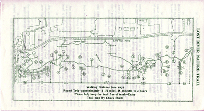
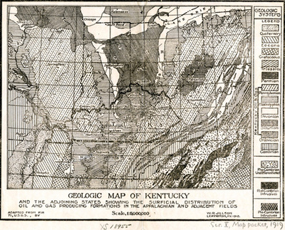
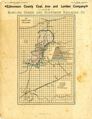
Maps can be about what is underground as much as what is on the surface or above ground. Men have been mining for minerals for centuries. The map of Edmonson County shows where coal and iron reserves are to be found. The Geologic Map of Kentucky shows gas producing formations according to their geologic ages. Much of Kentucky has caves such as Mammoth and Lost River that have been partially mapped. A lot is happening under Kentucky.
Printing is not supported at the primary Gallery Thumbnail page. Please first navigate to a specific Image before printing.

Follow

Switch View View Slideshow
 
  • Lost River Nature Trails by Chuck Shults

    Lost River Nature Trails

  • Geologic Map of Kentucky by Willard Rouse Jillson

    Geologic Map of Kentucky

  • Map Edmonson County Coal and Iron Company by Edmonson County Coal, Iron and Lumber Company

    Map Edmonson County Coal and Iron Company


Advanced Search

  • Notify me via email or RSS

Browse

  • Colleges, Departments, Units
  • Faculty/Staff SelectedWorks
  • Disciplines
  • Disciplines
  • WKU Journals/Peer-Reviewed Series
  • Conferences and Events
  • Authors

Author Corner

  • Author Submissions
  • TopSCHOLAR copyright form
  • Log into SelectedWorks

Links

  • WKU Libraries
  • WKU Homepage
  • WKU Libraries OA Hall of Fame
  • Kentucky Research Commons
  • Digital Commons Repositories

Gallery Locations

  • View gallery on map
  • View gallery in Google Earth
 
Digital Commons

Home | About | FAQ | My Account | Accessibility Statement

Privacy Copyright