

Preview
Creation Date
1796
Description
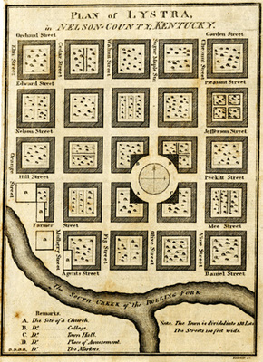
This small 5" x 8 1/4" plan is like that for Franklinville, created as a promotional and sale document and just like Franklinville, Lystra was not built. The plan includes a church, college, town hall, park and a market. The streets were to be 100 feet wide and the town was divided into 133 lots. The exact planned location is not known. It is believed to be near Gleanings, Kentucky.
Copyright open, copies of this map may be obtained for fee of $10.00. Contact spcol@wku.edu for more information.
Keywords
Maps, Mapmaking, Cartography, Kentucky, Urban Planning