
Preview
Creation Date
8-10-1966
Description
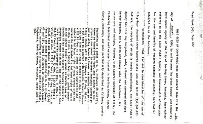
First page of transcription of deed dated 10 August 1966 between The Urban Renewal & Community Development Agency of the City of Bowling Green and 17 listed property holders.
$54,361.12 was paid to landholders for property described as:
Beginning at a point on U.S. Highways 68 and 231, known as Russellville Road, and a corner to the property now owned by Western Kentucky University and an alley formerly known as Hardin Lane or Alley; thence with the highways S 38 deg. 03 min. W 564 feet to a corner with Lincoln Street; thence with the line of Lincoln Street N 54 deg. 23 min. W 622.41 feet to a point on the Louisville & Nashville Railroad right of way; thence with the Louisville & Nashville Railroad right of way N 35 deg. 31 min. E 542.52 feet to a point corner to the street formerly known as Hardin Lane or Hardin Alley and the Western Kentucky University property; thence with the line of the Western Kentucky University property S 56 deg. 11 min. E. 243.79 feet; N 35 deg. 13 min. E 230.62 feet; S 59 deg. 40 min. E 122.51 feet; S 33 deg. 14 min. W 238.26 feet and thence S 56 deg. 22 min. E 273.49 feet to the point of beginning on U.S. Highways 68 and 231 being 8.05 acres or 350,722.85 square feet, according to a survey by Daniel & Tippit, Engineers, Bowling Green, Kentucky, dated June 15, 1966.
Keywords
Western Kentucky University, Jonesville