
Preview
Creation Date
2022
Description
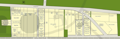
This map was created using the 1963 Jonesville property map created for the Urban Renewal Commission by Scruggs & Hammond. Many names on the original map were misspelled, which suggests a lack of care for the residents. We have corrected misspellings based on local knowledge. Properties acquired further northeast and east of those shown here were acquired as early as 1957 by purchase or condemnation suits. The shadows indicate approximate locations of roads and WKU athletics faciltiies in 2022.
- Herschel & Mary Austin
- Corinne Bailey
- Florence Bailey
- James Bailey
- Porter Bailey
- Virgil Bailey
- Mabel Barnett
- Fred & Myra Beeler
- Sue Blakely
- Bettie Blewett
- M.M. & Delia Blewett
- Thomas & Lucille Burton
- Margie Butts
- Emma Caldwell
- Floyd Cook
- Mrs. Lennie Cox
- Arnold Creeson
- Cherry Duncan
- Corinne Edson
- Houston Edson
- Ovella Edson
- William Edson
- Mrs. Lee Ferrill
- S.R. & Lorene GIllian
- Bill Hardin
- Macy Harding
- Ireland Hobson
- William Horner
- Madie Jarrett
- H.H. & Irene Johnson
- C.W. Lampkin
- Charles Loving
- Robert & Fannie Loving
- Mary McGinley
- Mt. Zion Baptist Church
- Lula Patterson
- Robert & Susy Potter
- Helen Ragland
- James & Aida Scott
- Gonzella & W.M. Simmons
- Jessie & Hazel Taylor
- Maxie Taylor
- Wick Taylor
- Charles Turner
- Edgar & Irene Walker
- George & Christene White
- J.W. Williams
- Jasper Woods
- L.V. Woods
- W.S. Yarbrough
Keywords
Jonesville, Diddle Arena, Maps