

Preview
Creation Date
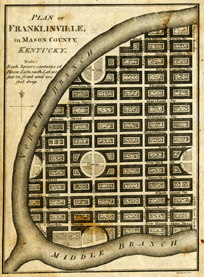
1796
Description
Small plan 5 1/2" x 8 1/4" of Franklinville in Mason County. Each square represents sixteen house lots, each with 100 feet in front and 200 feet deep. The streets are named for states, presidents and prominent Kentuckians intersected by streets named for trees. Public parks were included as well. This proposed town was to be situated between the north and middle forks of the Kentucky river. This map was created as a promotional tool in selling lots, however, the scheme failed and the town was never built.
Copyright open, copies of this map may be obtained for fee of $10.00. Contact spcol@wku.edu for more information.
Keywords
Maps, Mapmaking, Cartography, Kentucky, Urban Planning