  • Home
  • About
  • FAQ
  • My Account
TopSCHOLAR®

TopSCHOLAR®

Home > Online Resources > 2011: Maps & Mapmaking > Thematic Maps

2011: Finding Our Way: Maps & Mapmaking

Thematic Maps

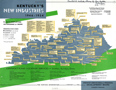
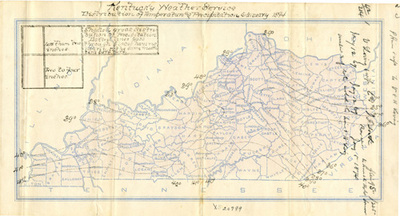
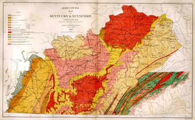
All maps have a theme generally about a geographical place. Some maps are less about place and more about a subject such as an political partisanship or economic development. The maps in this section tell us about Kentucky industry, agriculture and weather.

Printing is not supported at the primary Gallery Thumbnail page. Please first navigate to a specific Image before printing.

Follow

Switch View View Slideshow
  • Distribution of Temperature and Precipitation
  • Agricultural Map of Kentucky and Tennessee
 
  • Kentucky's New Industries 1946-1954 by Kentucky Agricultural & Industrial Development Board

    Kentucky's New Industries 1946-1954

  • Distribution of Temperature and Precipitation by Kentucky Weather Service

    Distribution of Temperature and Precipitation

  • Agricultural Map of Kentucky and Tennessee by Julius Bien & Company

    Agricultural Map of Kentucky and Tennessee

 
« previous page
page 1 of 1
next page »


Advanced Search

 
  • Notify me via email or RSS

Browse

  • Colleges, Departments, Units
  • Disciplines
  • Disciplines
  • WKU Journals/Peer-Reviewed Series
  • Conferences and Events
  • Authors

Author Corner

  • Author Submissions
  • TopSCHOLAR copyright form
  • Log into SelectedWorks

Links

  • WKU Libraries
  • WKU Homepage
  • Digital Commons Repositories
  • Contact Us

Gallery Locations


View Image Gallery in Google Earth

  • View gallery on map
  • View gallery in Google Earth
 

This collection is part of the
Digital Commons Network

Architecture • Arts and Humanities • Business • Education • Engineering • Law • Life Sciences
Medicine and Health Sciences • Physical Sciences and Mathematics • Social and Behavioral Sciences

Digital Commons

Home | About | FAQ | My Account | Accessibility Statement