

Preview
Creation Date
1954
Description
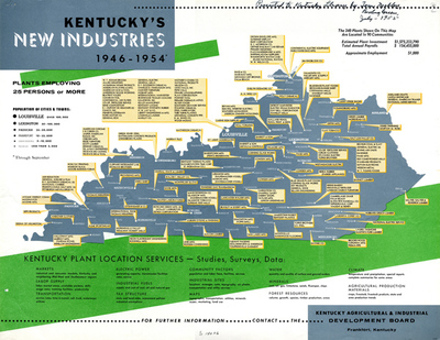
Thematic map showing the locations of Kentucky industries employing more than 25 people for the period 1946 through 1954. Created by the Kentucky Agricultural and Industrial Development Board to promote Kentucky with manufacturer's, this map lists incentives to locating in the Commonwealth such as water, markets, climate and tax structure.
Copyright open, copies of this map may be obtained for fee of $10.00. Contact spcol@wku.edu for more information.
Keywords
Maps, Mapmaking, Cartography, Kentucky