

Preview
Creation Date
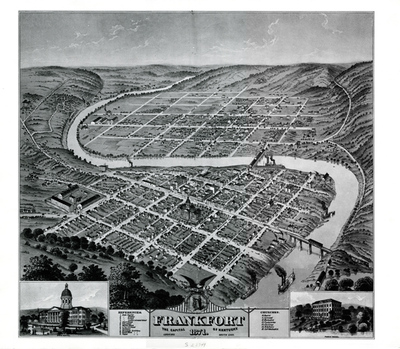
1871
Description
This bird's eye view of Frankfort shows us the seat of government in 1871. The state capitol building is located near the center of the map and is represented in an inset drawing. The second inset highlights the three- story public school building. There are steamboats on the Kentucky river and trains using the railroad bridges indicating that the city is a hub of commerce. Also included is the state prison on the left.
Copyright open, copies of this map may be obtained for fee of $10.00. Contact spcol@wku.edu for more information.
Keywords
Maps, Mapmaking, Cartography, Kentucky, Frankfort